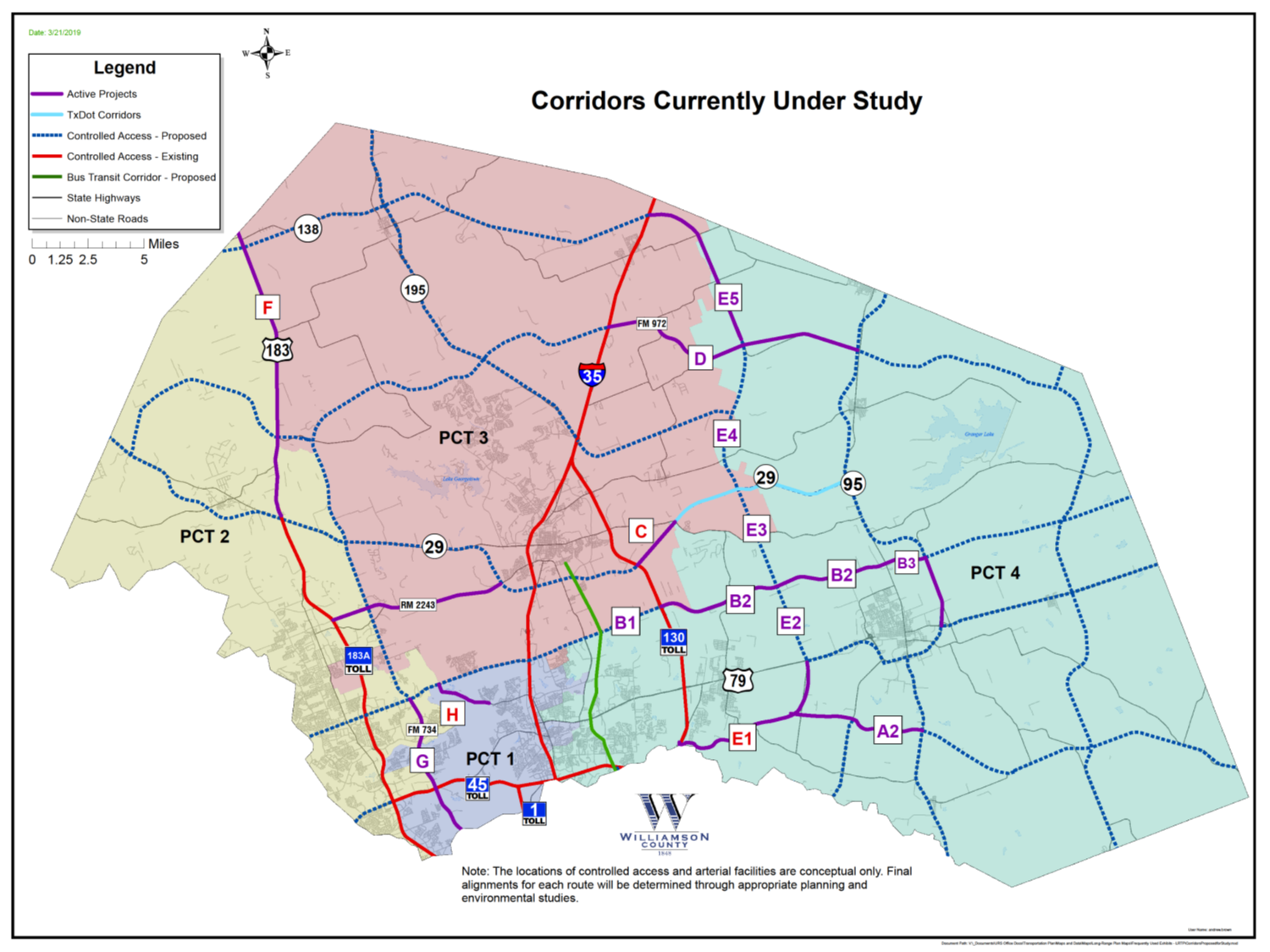
Williamson County is studying corridors to enhance mobility in the County. For information on each study click on the corridor below.
Southeast Loop (E1)
East/west connector between SH 130 and FM 3349 and north/south travel to US 79 in Precinct 4.
Corridor C / SH 29 Bypass
Connector from Sam Houston Avenue at Patriot Way to SH 29
Corridor H / Sam Bass Road
Sam Bass Road from FM 1431 to Wyoming Springs Drive
Corridor D / Ronald Reagan Extension
Ronald Reagan from IH 35 to SH 95
Corridor F / US 183
US 183 from SH 29 to Williamson County line
The County believes community input makes better projects, and we encourage you to share your comments and to stay involved.
- Attend a public meeting. Please check individual project pages for upcoming meetings.
- Share comments by:
- Completing a survey or comment card at a public meeting
- Email: roads@wilco.org
- Mail: Williamson County Public Information, 710 S. Main St., Ste. 101, Georgetown, TX 78626
- Reach out to the County and project teams for more information or to schedule a meeting
If you would like to receive e-mail updates, please send an email to roads@wilco.org with the specific corridor you are interested in and "Updates” in the subject line.
The corridors are being studied as part of the Long-Range Transportation Plan (LRTP). The LRTP is a guiding document that Williamson County is responsible to develop to plan for accommodating transportation and mobility now and in the future. This plan has been updated and will continue to be updated based on current needs, population projections, anticipated future mobility needs, and safety of Williamson County. The planning process to develop the LRTP involves working with the public, cities, neighboring counties, and transportation and planning agencies to gather input and coordinate connectivity and mobility.
The current amendments to the LRTP outline a network of roadways that will improve safety and mobility across the County, and include a maps of proposed controlled access facilities and proposed arterial facilities. The locations of the controlled access facilities and arterial roadways are conceptual only to show general locations and connections needed. Final alignments for each route will be determined through appropriate planning and environmental studies.
Engineering firms have been hired for each of the studies to conduct public involvement, environmental studies, preliminary engineering, and schematic development. Construction funding has not been identified at this time.
The Controlled Access Facilities map below shows the corridors being studied in red.